


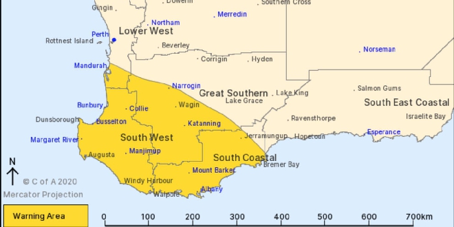
A severe weather warning has been issued for the state's south west including Mandurah.
A strong cold front is expected to sweep over the coast from Saturday evening into Sunday morning.
Damaging winds with gusts of up to 100km/h are possible between Windy Harbour and Mandurah.
"This front is expected to be windier than a typical front and is likely to produce kind of weather that is only seen around 2 times per year," a Bureau of Meteorology spokesperson said.
LATEST ALERT:
Get ready now for severe weather in parts of the Perth Metropolitan, Great Southern, South West, Lower South West
If you live in Albany, Bunbury, Busselton, Katanning, Mandurah, Manjimup, Margaret River, Mount Barker and Narrogin you need to get ready now for the severe weather coming tonight.
This front is expected to be windier than a typical front and is likely to produce kind of weather that is only seen around 2 times per year.
WHAT TO DO:
DFES has these tips to help you and your family get ready now:
- Store or weigh down loose objects around your home like outdoor furniture that could be picked up and thrown by strong winds, causing damage or injury
- Ensure your emergency kit is complete including a battery operated radio, torch, spare batteries and first aid kit
- Ensure pets and animals are in a safe area
- Move vehicles under cover
- Boat owners should securely moor their boats
- Campers should find safe shelter away from trees, powerlines, storm water drains and streams
- Unplug electrical appliances and avoid using landline telephone if there is lightning.
If you are away from home contact family or friends to prepare your property.
WEATHER DETAILS:
Bureau of Meteorology advised a strong cold front will cross the west coast during Saturday evening and Sunday morning. An associated deep low pressure system will move over parts between Margaret River and Albany Sunday morning.During Saturday evening in western parts of the warning area between Mandurah and Windy Harbour DAMAGING WINDS with gusts to 100 kilometres per hour are possible and could cause DAMAGE TO HOMES AND PROPERTY. DAMAGING WINDS are expected to extend throughout the warning area early Sunday morning, and then contract to eastern parts of the warning areas late Sunday morning. Conditions are expected to ease by Sunday afternoon.The worst weather is expected in parts between Bunbury and Albany.Tides are likely to rise ABOVE THE NORMAL HIGH TIDE MARK with VERY ROUGH SEAS and POTENTIAL FLOODING OF LOW-LYING COASTAL AREAS, especially near the Geographe coast.DAMAGING SURF CONDITIONS are likely which could cause beach erosion.
ROAD CLOSURES AND CONDITIONS:
Roads have not been closed.
Take extra care on the roads and do not drive into water of unknown depth and current.
Road information may also be available from Main Roads WA by calling 138 138 or visiting travelmap.mainroads.wa.gov.au or by contacting your Local Government Authority.
WHAT EMERGENCY SERVICES ARE DOING:
- DFES is monitoring the situation.
IF YOU NEED ASSISTANCE:
- If your home has been badly damaged by a storm, call the SES on 132 500
- In a life threatening situation call 000
After a storm SES volunteers make temporary repairs to homes that have been badly damaged, such as roofs that have been ripped off or large fallen trees on homes or cars. Please contact your insurance company to organise permanent repairs.
KEEP UP TO DATE:
Visit www.emergency.wa.gov.au, call 13 DFES (13 3337), follow DFES on Twitter: https://twitter.com/dfes_wa, Facebook: https://facebook.com/dfeswa/
During a power outage, your home phone, computer or other electronic devices connected to the NBN will not work. Include a battery powered radio in your emergency kit.
 Warnbro man charged with more child abuse, animal cruelty offences
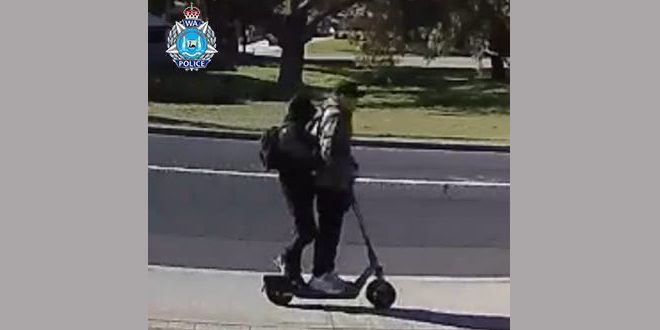 Teen threatened, robbed by offenders on e-scooter in Mandurah
 Labor candidate for Secret Harbour Georgia Tree vows to fight for locals
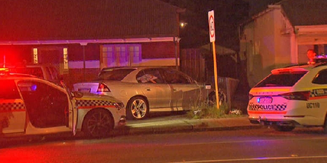 Safety Bay man arrested after Perth police pursuit comes to crashing end
 Port Kennedy before and after school care provider fined $33k after 'distressed' boy left alone in room
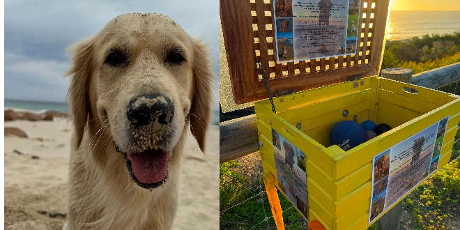 Dog ball library created at Dawesville beach in memory of beloved pet
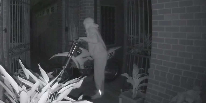 WATCH: Police investigate South Yunderup motorbike theft as sellers warned to stay vigilant
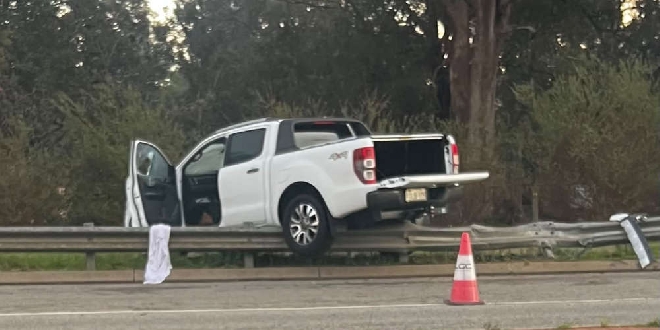 Woman, child taken to hospital after car crashes into guard rail in Greenfields
 WA Police warns Telstra outage is impacting calls to triple-zero